We were travelling along the Black Coast in Turkey, on our way to Georgia. So when we were looking for a spot to camp for the night we ended up in the Black Diamond Geopark, and the tarmac is really Black as well (I will explain later). Despite all this “blackishness”, the black Sea coast -so far- was lush green and hilly with difficult to reach coastlines. I decided to go for a ride here.

While looking on the (digital) map I noticed that despite the hilly terrain -that has quite steep slopes by the way- a railroad was drawn. A railroad? Here? When you drive around here, it is quite clear that road construction is hard enough, let alone building a railroad that requires inclines of preferably lower than 1.5%.
That made me curious so I decided to ride in westerly direction and that answered two questions actually. More about that later.

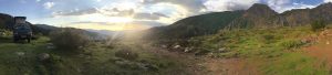
The few roads that wind through this area are really winding and really going up and down. We had a nice spot in a secluded cove close to the seaside and Cape Taffoni. This meant I could start at sea level. That also meant climbing right away. The humidity together with the sun made it quite quickly a hot ride. Apart from the heat, riding to the west was a matter of going up and down along the small asphalt roads most of the time, occasionally alternated with gravel and even a stretch of cobble stones.

The villages and solitary houses were tucked away in the green leaves. Finally I reached a somewhat bigger village (Kandilli) where one end of the railroad was situated. The reason for it’s existence was a coal mine. So that’s the reason for a railroad. And that is also why it is called Black Diamond Geopark here as well: the coal in the ground. So that was two questions answered.


On the way back I could feel some extra resistance during the climbs; the black asphalt had become so hot it was now turning soft. I could see the tread pattern of the tyres. With that observation made I decided to go back to the beach and take a cooling plunge in the Black Sea.