
While I was cycling the other day, I realized that I have not written anything about it lately. Why is that? I asked myself. and what have cows to do with that? I will come to that later.

For me, cycling is a way to relax, but also a time to think and contemplate besides the physical challenge. So I started thinking about why, and how. But this time after the ride.
When planning a cycling route I try to pick a goal: for example a mountain peak or pass. Or perhaps a lake, village or religious object that is located in a special place. If possible I try to make a loop of it. I must admit that sometimes picking a goal has also to to with how others will perceive it: when you say you have climbed mount Olympus, more people will be able to visualize this than, let’s say, you have climbed Mount Otepura-Dudi that nobody ever heard of.
When we started travelling I looked forward to ride special places with just the right amount of challenge, but in reality I have a hard time finding these special (mountain bike) places, simply because they are hardly existing outside the western world. Albania and Turkey, I admit, regularly had some nice unknown locations that matched my expectations. In Bulgaria and Macedonia three times I came across a bike park, closely connected of course to a winter sport area but then it is more focussed on down hill. And winter was hard this year so when I finally found a nice mountain range, it was still covered in snow… But other than that, there doesn’t seem to be (cross country) mountain biking going on.
Why is that? I asked myself. Well I guess it has to do with infrastructure. Contrary to the Alps, all other mountain ranges I have encountered -so far-, have a less dense track network. Making it difficult to create a suitable loop. Also, the tracks are created from a different requirement. In the Alps it is these days mainly tourism (walking, cycling) while in the Balkans and Caucasus, it is mainly herding of cows, sheep and goats. Consequently, the tracks are narrower, steeper and have a more loose surface with bigger stones. The network that is needed to reach small (summer) settlements is more suited for 4×4 cars and trucks. These tracks are also steeper (quite often long sections of ~30% and some more) and the surface is therefore more loose with bigger stones because the vehicles have to work hard climbing those slopes.
I think I can say that, in the western world, when I was riding in the “wild” I was actually still riding in a carefully constructed and maintained wilderness, compared to where I have been riding the last year. I think I felt disappointed a bit in some cases and that resulted in less motivation to write about it. But in general the rides aren’t less adventurous; they’re just different.

My last trip is a fair example of the differences compared to what I was used to at home. I created a loop of just under 40 km and an expected 1300 m of climbing. Of course planning and navigation can only be as good as the available map material, which isn’t much: a 1:500.000 scale paper map and openstreet GPS mapping for details. The plan was to follow a dotted line (walking track) to a solid line (gravel track) to a mountain pass and then down to a village, after that it would possibly be asphalt for a short stretch, changing back to a forest road, that would be leading into a walking track with a mild short climb before reaching the forest road back to the staring point.


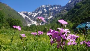
Well…the first part worked out fine. The track went through forest and meadows, the surface was a bit muddy, making the tyres twice as wide and the surface a bit slippery. After that it went up to the pass, along nice scenery with small summer settlements. But when reaching the pass and highest point of the route at about 9km, I came across a blue porta-cabin saying “police” on the wall. We encountered this situation before in Georgia, but only close to the borders with Russia because of border disputes. Now I was in the middle of the country. While passing the cabin, three military dressed guys stepped out, complete with AK-47. I noticed that I kind of surprised them by showing up, but finally they waved to stop. I did. The asked my passport so I gave them a copy that I always carry. I don’t usually carry the original. It took some 20 minutes to be cleared, telephone calls were made, most of it in Georgian. I could notice that the word GPS was used regularly. Despite modern smart phones with internet access and all other fancy stuff (also used by military) apparently a “stupid” Garmin GPS receiver is still suspicious.


Weather had changed for the worse in the meantime: mist and rain, but I continued my route. Just before reaching the village I came across another checkpoint but this time, after a short stop and explaining I came from the other checkpoint, a telephone call was made to confirm and I could continue. Then there was the expected stretch of asphalt. Riding through this village, being far a way from everything, I noticed there was some kind of factory. Perhaps a leftover from the communist era. I continued along the forest road which was quite nice. It followed the side of a mountain without too much steep ups-and-downs.

But then, 7km from the end, the hard (mandatory?) part was there again. GPS mapping indicated a forest track, but in reality it was a track maintained by cows only. Of course there was no alternative to be found. So I had the usual choice of going back or to push on. I choose the latter. Sometimes it was well trodden muddy and narrow track, then it was an almost invisible direction through a meadow with hip-high grasses and thorny growth. Not so much of an incline but I had to walk half of it. Moments like this are not part part of my expectations. But there is always something to learn from these experiences. in this case: cows are lousy at building or maintaining a trail.


Of course, to avoid such things, I could just decide to follow the available roads while cycling. There is not too much other other traffic anyway, but as always I hope to ride a nice mountain-bike-worthy trail, so I guess I will keep on pushing that bike every now and then… and besides that, how often do you come across a military checkpoint in the Netherlands?


Makes for a different kind of adventure. But I can remember some tracks we’ve ridden together in the Ardennes and the Alps also left the impression to be maintained by anything but humans.
Keep on writing these nice stories and travel safe.
Greetings from those who remained in the flat country.
Edwin
Thanks Edwin. it’s true we even had a dry river bed which we thought was the track…I’ll keep on writing.